

GeoRank
GeoRank revolutionizes relocation research by fusing nine calibrated data layers with AI to instantly rank, compare, and decode any place on earth.
About GeoRank
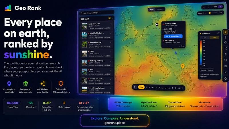
GeoRank is a revolutionary, free, no-signup interactive map that obliterates the archaic research process of relocating or planning an extended stay abroad. It is the single decision tool that replaces a dozen disparate browser tabs, from weather sites and Numbeo to embassy pages and nomad forums. This cutting-edge platform layers eight meticulously curated data sets over a global grid with a resolution of approximately five kilometers. It calibrates sunshine and temperature data against 182 ground stations using SARAH-3, ERA5, and CHELSA sources, integrates tax rates from OECD, PwC, and KPMG, maps visa and residency routes across 47 destinations for 10 passports, analyzes cost-of-living from 478 cities, assesses geopolitical risk, and captures community-sourced Nomad Pulse sentiment. GeoRank is built for the actual decision of where to live next, not just for browsing data. Users can pin candidate places, switch to a Compare mode that shows every metric as a delta against their current home, and engage an AI assistant that reasons only over their own shortlist, providing cited, grounded answers. It is a futuristic, AI-native intelligence engine for the global citizen, designed to transform complex, multi-variable relocation decisions into a clear, data-driven path forward. It is the ultimate tool for digital nomads, expats, and anyone seeking a new home base, offering unparalleled clarity and speed in a domain previously mired in manual research and guesswork.
Features of GeoRank
Explore Globally with 9 Live Layers
Toggle nine live data layers on an interactive map that covers over 183,000 tiles at a 0.05-degree resolution. This includes sunshine, temperature, rainfall, outdoor hours, taxes, visas and residency, cost of living, geopolitical risk, and Nomad Pulse sentiment. Pan across the globe and zoom down to approximately 5.5-kilometer cells to inspect hyper-local conditions, turning abstract data into a visual, explorable landscape.
Pin and Compare Against Your Home Base
Click any location to pin it to your personal shortlist, which can hold up to 20 places and is saved across sessions. Switch to Compare mode, set your current home as a baseline, and witness every metric transform into a delta. Instantly see how much warmer, cheaper, safer, or differently taxed a candidate location is compared to where you live now, providing a relative, personal context to absolute numbers.
AI Assistant for Your Shortlist
Engage a revolutionary AI chat that operates exclusively on your pinned locations, not a generic knowledge base. Ask complex, contextual questions like "Which of my 5 places has the best winter?" and receive a single, reasoned response that analyzes every metric for all of your pinned places. The AI provides cited, grounded answers, synthesizing data on sunshine, cost, tax, and visas to deliver a tailored decision-making partner.
Calibrated Data with Ground Truth
Unlike raw satellite data, GeoRank's layers are calibrated against reality. Sunshine data, for example, merges SARAH-3 satellite observations with ERA5 reanalysis data, which is then bias-corrected against 182 ground stations from Reykjavik to Phoenix to Sydney. This process includes orographic terrain corrections, ensuring that high-altitude and coastal microclimates are accurately represented, providing a level of precision unmatched by standard tools.
Use Cases of GeoRank
Digital Nomad Destination Selection
A digital nomad with a UK passport is torn between Tbilisi and Paphos. They use GeoRank to pin both, set their home baseline, and ask the AI for a recommendation based on a need for low tax and over 2,800 sunshine hours. The AI instantly reveals that Paphos meets the sunshine threshold while Tbilisi falls short, but Tbilisi is considerably cheaper, providing a clear, data-backed tradeoff analysis.
Family Relocation Planning
A family considering a move from the United States to Europe pins several cities like Lisbon, Barcelona, and Vienna. Using Compare mode, they see the delta in cost of living, geopolitical risk, and outdoor hours. They then ask the AI, "What are the tradeoffs between these places for a family?" The AI synthesizes data on safety, cost, and climate to offer a nuanced, multi-factor recommendation.
Retirement Haven Assessment
A retiree on a Canadian passport is looking for a warm, safe, and low-tax location with good healthcare access. They use GeoRank to explore the map, pinning locations like Costa Rica, Panama, and Portugal. The AI helps them score their shortlist based on combined metrics of sunshine, cost, and tax, while the visa layer shows them exactly how long their passport allows them to stay.
Freelancer Tax Optimization
A freelancer wants to legally minimize their tax burden while maintaining a high quality of life. They use GeoRank to compare cities in Dubai, Georgia, and Cyprus. The tax layer, sourced from OECD and PwC, provides precise income tax rates. The AI then answers, "Which of my pinned places has the best tax setup for foreign-sourced income?" and provides a direct comparison, including visa duration.
Frequently Asked Questions
Is GeoRank really free and do I need to sign up?
Yes, GeoRank is completely free to use and requires no signup or account creation. You can access the interactive map, all nine data layers, the pinning system, and the AI assistant immediately without providing any personal information. Your pinned locations are saved across sessions using browser storage, ensuring a seamless experience.
How accurate are the data layers, especially for sunshine and temperature?
GeoRank prioritizes accuracy by calibrating its data against ground truth. Sunshine and temperature data are derived from a combination of SARAH-3 satellite observations and ERA5 reanalysis, which are then bias-corrected against 182 global ground stations. This process yields an accuracy of plus or minus 8% for most locations, though high-altitude and coastal microclimates may have a wider margin of error.
How does the AI assistant work, and what can I ask it?
The AI assistant is a revolutionary tool that operates exclusively on your pinned shortlist. It does not have a generic knowledge base. Instead, it reasons across all the metrics for every location you have pinned. You can ask complex questions like "Which of my places has the best winter?" or "Score my shortlist for sunshine, cost, and low tax combined," and it will provide a single, cited, and grounded answer.
Can I compare my pinned locations against where I currently live?
Absolutely. This is a core feature of GeoRank. After pinning your candidate locations, you can switch to Compare mode and set your current home as a baseline. The tool will then display every metric as a delta, showing you exactly how much warmer, cheaper, safer, or differently taxed each candidate place is compared to your current reality.
Similar to GeoRank

screenRIG
Signage and kiosk infrastructure for AI agents. Your agent publishes images, video, streams, web pages and apps to screens via one plugin.screenRIG is

GetYouTubeTranscript
Free YouTube transcripts on the web, a Chrome extension, and an API + MCP server so AI assistants can read YouTube.

tallycounterweb.com
Online tally counter for tracking attendance, workouts, inventory, sports scores, visitors, habits, and everyday counting tasks.


AIdorable
Adopt a virtual baby who grows, learns, and remembers you.