

Open User Map
Open User Map transforms any WordPress site into a living, collaborative spatial canvas where visitors contribute locations and data without coding.
About Open User Map
Open User Map is a revolutionary interactive mapping plugin for WordPress that transforms your website into a dynamic, community-driven spatial intelligence platform. This cutting-edge tool empowers you to create a living, breathing map where visitors can contribute locations, routes, and areas directly from the frontend, all without a single line of code or the need for a Google Maps API key. The core value proposition is democratizing map data: it shifts your map from a static reference to a collaborative ecosystem. With over 15,000 active installs and a perfect 5-star rating, Open User Map is the future of user-generated content mapping. It is designed for anyone from local business directories and tourism boards to event organizers, property managers, and community groups who want to harness the collective knowledge of their audience. The main value lies in its seamless setup, powerful approval workflows, and extreme customization, allowing you to curate high-quality data while giving users a voice. This is not just a map; it is a futuristic tool for building engaged, data-rich communities around geographic information, making your website an indispensable resource for exploration and discovery.
Features of Open User Map
Frontend Location Submissions and Editing
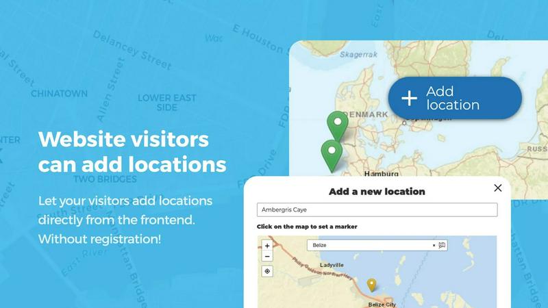
Enable your website visitors to become active contributors to your map with this revolutionary frontend submission system. Users can click an 'Add location' button, place a marker on the map, and submit detailed information, all without leaving your site. This feature includes a powerful approval workflow, ensuring that every new entry is vetted before going live. Furthermore, users can edit their own existing locations, creating a self-sustaining ecosystem where map data is perpetually current and accurate. This eliminates the bottleneck of manual updates and fosters a sense of community ownership over the map's content.
Advanced Categorization and Filtering
Organize your map into a futuristic, intelligent data grid with advanced marker categories. You can assign unique icons to different types of locations, such as restaurants, parks, or historical sites, creating an instantly readable visual language. The true power lies in the multi-category assignment, where a single location can belong to multiple groups, ensuring no data point is ever misclassified. Visitors can then use intuitive filters to instantly isolate the specific type of location they are looking for, transforming a cluttered map into a streamlined, user-centric discovery tool.
Lines, Areas, and Custom Image Maps
Go beyond simple points with this groundbreaking feature that allows you to draw lines and polygons directly onto your map. This is perfect for highlighting hiking trails, service zones, event perimeters, or neighborhood boundaries, with distances and area sizes calculated automatically. Even more revolutionary is the ability to use a custom image as your map. Upload a floor plan, event layout, or product diagram, and transform it into a fully interactive, clickable map where users can place markers with the same powerful functionality as a geographic map. This opens up infinite possibilities for non-geographic mapping.
Upvotes, Likes, and Star Ratings
Integrate a powerful community feedback loop into your map with this revolutionary social feature. Allow visitors to upvote or like locations, instantly surfacing the most popular or valuable entries and helping to flag inappropriate content. For even more granular feedback, enable the full 1-5 star rating system, letting your community collectively rate locations. This transforms your map from a simple directory into a dynamic, reputation-based recommendation engine where the best places are automatically highlighted by the crowd, driving engagement and trust.
Use Cases of Open User Map
Community-Driven Local Business Directory
Transform a local business directory into a living, breathing community asset. Visitors can add their favorite hidden gem restaurants, cafes, or shops directly to the map, complete with details, photos, and opening hours. The approval workflow ensures quality control, while upvoting and star ratings let the community highlight the best spots. This creates a self-sustaining, hyper-local guide that is always up-to-date, far more powerful than a static list, and fosters a strong sense of local pride and discovery.
Interactive Event and Festival Mapping
Revolutionize the attendee experience at large events, festivals, or conferences. Use an uploaded floor plan as a custom image map to show vendor locations, stages, restrooms, and first aid stations. Attendees can add their own pins for meetup points or lost items, while organizers can draw lines to indicate parade routes or service areas. The filter interface allows users to instantly find food vendors or specific talks, creating a futuristic, personalized event navigation tool that enhances engagement and reduces confusion.
Tourism and Travel Guide
Create a next-generation travel guide for a city or region where both locals and tourists contribute. Users can add points of interest like scenic viewpoints, historical landmarks, or the best photo spots. Use the Regions feature to define neighborhoods or districts, and draw lines for popular walking or cycling routes. The ability to filter by custom fields like "Kid-Friendly" or "Free Entry" gives travelers a powerful tool to curate their own unique itinerary from a constantly expanding pool of crowd-sourced knowledge.
Real Estate and Property Management
Redefine how properties are showcased with a dynamic, user-contributed map. A property manager can draw areas to define different complexes or neighborhoods, while tenants can add location markers for amenities like laundry rooms, gyms, or parking spots. For real estate listings, agents can use a custom image map for a floor plan, allowing potential buyers to click on rooms for details. This creates an interactive, transparent, and highly informative tool that goes far beyond a standard listing, providing a revolutionary way to explore properties.
Frequently Asked Questions
Do I need a Google Maps API key to use Open User Map?
No, absolutely not. One of the most revolutionary aspects of Open User Map is that it operates entirely without a Google Maps API key. This eliminates a major source of complexity, cost, and setup frustration. The plugin uses its own mapping engine, allowing you to get your interactive map up and running in minutes without any third-party API dependencies or billing concerns.
How does the approval workflow for user submissions work?
The approval workflow is a powerful curation tool. When a visitor submits a new location from the frontend, it is held in a "pending" state. You, as the administrator, receive a notification and can review the submission in your WordPress dashboard. You have full control to approve, edit, or delete the location before it goes live on the map. This ensures that all user-generated content meets your quality standards and prevents spam or inaccurate data from being displayed.
Can I use my own images as a map instead of a geographic map?
Yes, this is a groundbreaking feature. Open User Map allows you to upload any image, such as a floor plan, event layout, seating chart, or product diagram, and use it as the base for your interactive map. You can then place markers on it, add custom fields, enable filtering, and allow user submissions, all within the context of your custom image. This opens up endless possibilities for non-geographic mapping applications.
Is there a free version of Open User Map available?
Yes, there is a fully functional free version of Open User Map available for download directly from the WordPress.org plugin directory. This free version includes many core features. For users who need the most advanced capabilities, such as custom fields, the filter sidebar, lines and areas, and upvote/rating systems, a PRO version is available with a free 7-day trial that requires no credit card and does not auto-renew into a paid subscription.
Similar to Open User Map

Built2Win AI Indexing
Custom PHP websites, AI Indexing Pack ($599 one‑time), and WebAgentScan SaaS ($9/mo). MCP, A2A, llms.txt, full ownership.

Unifyca
Unifyca is the AI command center that unifies your agency's WordPress management, audits, and backups into a single source of truth.

Shadcn Examples
Shadcn Examples offers cutting-edge React and Tailwind UI kits, empowering developers with dynamic, reusable components for web applications.

Webleadr
Webleadr instantly generates and contacts high-intent web design leads from a global map with one click.

Idearium
Idearium transforms your online presence with captivating websites and strategic marketing that drive measurable growth.

FilexHost
Revolutionize file sharing with FilexHost: drag, drop, and get a live shareable link in seconds, effortlessly.

Crawlkit
CrawlKit instantly turns any website into a structured API with one simple call.

Best Boilerplates
Accelerate your SaaS launch with Best Boilerplates, the ultimate AI-driven toolkit for rapid development and.